

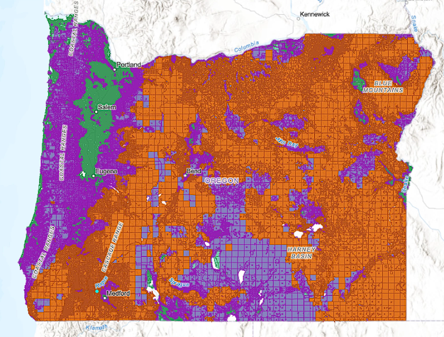
Salem, Ore. – Following a February 17 press conference by Oregon House and Senate Republicans addressing the controversial statewide wildfire risk map, the Eastern Oregon Counties Association (EOCA) is formally requesting that the state of Oregon repeal the wildfire hazard map adopted under SB 762 (2021).
The criticism comes even after revisions had been made to the map by officials with the Oregon Department of Forestry and scientists at Oregon State University. Their revisions were announced in January after a yearlong revision that included a period of public comment. The original maps had been proposed in 2022.
The EOCA joins a growing coalition of rural leaders, property owners, and lawmakers who argue that the wildfire risk map is deeply flawed, disproportionately impacting rural Oregonians by devaluing properties, increasing insurance costs, and imposing excessive land-use restrictions.
“The wildfire hazard map was created with good intentions, but it has caused more harm than good for Eastern Oregon residents,” said Crook County Commissioner Seth Crawford, EOCA lead on the Oregon Wildfire Risk Map. “Its inaccuracies and overreach threaten the livelihoods of rural communities. We urge the state to repeal this map and work collaboratively on wildfire policies that truly protect Oregonians without unfairly burdening them.”
“EOCA stands with House Republican Leader Christine Drazan (R-Canby), Senator Noah Robinson (R-Cave Junction), and other state lawmakers advocating for a repeal. The association remains committed to working with state officials to develop a more accurate, science-based approach to wildfire mitigation that balances public safety with property rights,” the statement read.
“There is a concern that the Oregon Wildfire Risk Map will be further weaponized and become the Oregon Wildfire Enforcement Map”. Said EOCA Co-Chair Paul Anderes, Union County Commissioner.
Many Eastern Oregon Counties Association individual members have already signed on to a latter to be sent to the Legislative, Executive and involved State Agencies concerning the Oregon Wildfire Risk Map.
“The wildfire hazard map is informed by decades of research on the nature of wildfire, where it begins, why it exists, and what the challenges are,” said Andy McEvoy, a wildfire scientist at Oregon State University. “The wildfire hazard map is intended to provide property owners and policymakers with an objective foundation for making decisions.”
According to Oregon Senate Bill 82, insurance providers are not allowed to use the map in calculating rates or determining coverage qualifications.
Just yesterday, Central Oregon Daily detailed the claims in a story by a Sisters homeowner, Tom Bracken, who is blaming the State’s map for causing the sale of his home to fail to go through twice.

 on Robert Pamplin Jr.")


 is formally requesting that the state of Oregon repeal the wildfire hazard map adopted under SB 762 (2021).)